The Houston suburb of The Woodlands has been called an “invisible city” for the dense tree canopy that shrouds the extent of its development. It is invisible perhaps in another way: It’s not a city at all, but rather a patchwork of special districts, service contracts and interlocal agreements—a tenuous marvel of public-private partnership. But that could soon change.
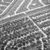
The popular perception is that Texas’s metropolitan areas are sprawling all over the place because the state has so much land. The truth of the matter is a little more complicated, however. Yes, all the metros in Texas are sprawling – but they’re densifying as well. And when you “net it out,” the density is winning over the sprawl in the big metros – while the sprawl is winning over the density in the smaller ones.
The Texas Supreme Court has settled it: Houston's historic preservation ordinance is not a form of zoning, which is expressly banned in the city charter. The decision seems to clear the way for more local experimentation with urban design and development rules.
Just don’t call it zoning.
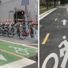
The city has eight months of ideal cycling weather each year and has taken some sizable steps in building out its bike infrastructure in the past decade. But is anyone outside of Houston paying attention?
The development of townhomes in Houston predominantly has taken place in high-amenity neighborhoods where gentrification has already occurred. The latest report from the Kinder Institute also shows new townhome construction is growing in at-risk neighborhoods, a trend that appears to be speeding gentrification in those communities.
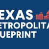
The Texas Metropolitan Blueprint lays out recommendations
for policies that address the most important
economic development, land use, housing, infrastructure,
and transportation challenges of the state’s metropolitan
areas.
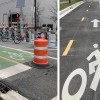
When a west Houston intersection was retrofitted with infrastructure to protect pedestrians, City Observatory’s Joe Cortright called the redesign hollow and ‘performative.’ But it’s not that simple.
Whether you ride a bike full time or part time, just for fun or for transportation, BikeHouston’s new executive director wants to make it safer to ride a bike in Houston. It’s why he left New York to come here.
Urban planners and designers sometimes think they have an exclusive “lock” on an understanding of place. But in fact everybody can develop their own “place gene.”
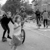
Pedestrians and bicyclists accounted for 38% of all roadway deaths in Houston in 2019 — a 3% increase from 2018. Overall, 647 people were killed in fatal crashes in the Houston area in 2019, according to NHTSA data released in December. Prioritizing speed on local roads is the dangerous status quo in the U.S., but many cities are taking action to try and make safety the priority.
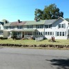
Influenced by the Garden City movement, Badin, North Carolina, is a small gem of urban planning whose design called for green space, residential areas and commercial development in proportionate amounts. The planning of small towns like Badin can serve as an example for larger cities as they continue to grow.
After a car-centric urban renewal plan irrevocably changed the town where he grew up, a young urbanist found the essence of Auburn, New York, in Southern California.
A failed plan to breathe life back into the economy of the beautiful, walkable city where I grew up left it half the place it once was, broke my father’s heart and shaped me as an urbanist.