After Hurricane Ida hit New Orleans in 2021, Kirt Talamo, a fourth-generation Louisianan, decided it was time to go. He sold his flooded home, purchased his grandmother’s former house on New Orleans’ west bank, which hadn’t flooded, and moved in. It felt good to be back within its familiar walls, but his mind was on the future.
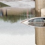
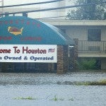
Hurricane season is here, and with it comes a familiar feeling of dread in the Greater Houston area, particularly about floods. But more than five years after Hurricane Harvey, Houstonians may be less inclined to buy flood insurance because of cost increases that have begun to roll out in the last year, with the latest data from the Federal Emergency Management Agency showing that prices could go up by 75% in Harris County alone.
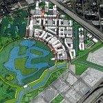
A proposal to transform a former landfill in southwest Houston into a mixed-use development with a flood control component recently caught the attention of statewide planners who recognized it for its contributions to resilience.
Water connects us, yet too often our region’s ongoing relationship with water presents itself as flooding that wreaks havoc and devastates all in its path. In the aftermath of Hurricane Harvey, many efforts have emerged to try to rebuild our relationship with water from one of harm to one of resilience.
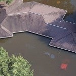
Natural disasters are increasingly common each year, affecting infrastructure and contributing to economic, social, health, and psychological hardships. When Hurricane Harvey hit Houston in 2017, it quickly amassed $125 billion in damages, displacing over a million people and their homes. Along with the economic toll of a disaster event, mental health concerns carry a cost that is difficult to measure.
The Kinder Institute’s Urban Data Platform warehouses over 50 datasets related to Hurricane Harvey and its aftermath. These resources can help researchers, agencies and organizations work toward ways to prevent and withstand the worst effects of the storms to come.
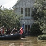
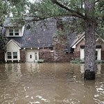
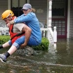
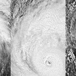
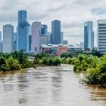
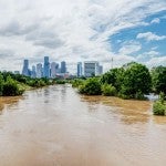
When it hit five years ago this week, Hurricane Harvey was an unprecedented disaster: 68 people dead, 200,000 homes damaged or destroyed, a half-million cars wiped out, $125 billion in damage.
Friendswood, a close-knit suburb southeast of Houston that routinely makes lists for being the “best place to raise a family,” also serves as a case study for how flaws in the federal approach to flood insurance and disaster recovery aid resulted in fractured outcomes even among similarly situated middle-class neighbors after Hurricane Harvey.
A new book serves as a guide for how cities can best learn from one another to design systems and build ways to endure the worst climate shocks to come. This includes Houston’s experience—both for what to expect from a changing climate and how to respond. Its authors say Houston has done several things right, but they also worry that future disasters could outpace these efforts.
Climate change is propelling more extreme weather events, including more precipitation and flooding, which means the need for more strategies such as buyouts has never been more urgent. As a concept, buyouts are fairly straightforward: the government buys up properties to remove them out of harm’s way, reducing the risk of loss of life, the need for future flood repairs, insurance payouts and other costs.
This webinar shares findings from the 2020 Texas Flood Registry Report, which provides an update on the health and housing impacts of Hurricane Harvey and other major storms.
What do trees, bike lanes, and billions in federal disaster aid have in common? They are some of the building blocks of Houston’s future—one that is safer, more equitable and better positioned to withstand future disasters. They’re also among the inventory of measures included in the Kinder Institute’s new Resilience and Recovery Tracker.
This report provides a geographic analysis of damage caused by Winter Storm Uri and highlights the unmet needs it uncovered. This assessment also analyzed damages from COVID-19 and Hurricane Harvey to better understand how these crises compound on different communities and to identify where recovery efforts might make the biggest impact.
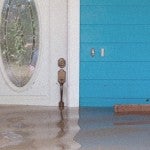
A new book, “In Too Deep” tells the story of Bayou Oaks, and its repetitive flooding, from the perspective of 36 mothers who are raising young children there. It follows the families across the course of more than a year, starting right after Hurricane Harvey flooded their homes, and tracking them across the recovery year and beyond as they work to restore their community for the third time in three years.
A new book revisits a flood that devastated San Antonio, claimed hundreds of lives and reshaped the city. It also led to the construction San Antonio’s first modern flood infrastructure and the development of the nation’s earliest environmental justice movements as Hispanic people confronted deadly disparities in housing and flood control.