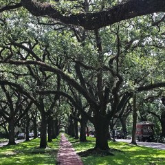
Among their many health benefits, trees play an essential role in reducing peak summer air temperatures. And, as one of the many indicators for vulnerability to heat and air pollution, they are a critical factor in mitigating the effects of climate change.
From 2011 to 2021, there was about a 9.9% decrease in overall average tree canopy in Harris County. More specifically, around 88% of community tabulation areas (CTAs) in the county experienced a decrease in average tree canopy coverage (CTAs are subdivisions of Harris County comparable to super neighborhoods). In fact, between 2015 and 2016, about 87% of census block groups in the county experienced a decrease.
These statistics were calculated using one of the two new UDP tree canopy datasets, which Houstonians can use as a starting point to, for example, map their neighborhood’s average tree canopy over time from 2011-2021, even going as far as researching local weather or construction events to account for these changes. Correspondingly, organizations and communities can use the data to determine the neighborhoods most in need of more trees: those especially susceptible to heat, prone to flooding, with less access to greenspace, etc.

Tree canopy benefits
According to the U.S. Forest Service, tree canopy is the leafy, green, overhead cover. Urban tree canopy, particularly, preserves wildlife habitats, assists stormwater drainage, conserves energy, provides shade and, put simply, beautifies cityscapes. During summertime months, only about 10% to 30% of the sun’s energy penetrates canopy, says the Environmental Protection Agency. The rest is either absorbed by leaves for photosynthesis or reflected back into the atmosphere. Thus, shade provided by trees — and even smaller plants such as shrubs or vines — can substantially reduce temperatures, lowering the energy needed to cool buildings and surfaces.
Trees also preserve water quality and reduce ultraviolet radiation and air pollution. In fact, according to a 2018 study published in the Journal of Forestry, they provide approximate annual benefits of $18.3 billion in air pollution reduction, carbon sequestration, and reduced building energy usage and pollutant emissions in urban areas in the U.S. More specifically, in 2015, the U.S. Forest Service estimated that Houston’s urban forest reduces residential energy costs by $53.9 million and runoff by $7.8 million per year. The overall estimated compensatory value of Houston's trees was estimated as a whopping $16.3 billion.
Finally, trees provide an abundance of physical and mental health benefits. Research suggests that offering accessible greenspaces consequently boosts social connection, alleviates stress and promotes active living. One study even associates greener areas with reduced mortality related to cardiovascular disease.
In short, trees are perhaps one of the most uncontroversial parts of nature. Investing in urban trees nationwide could offer a more cost-effective approach to decreasing pollution and increasing social cohesion. However, despite all of their perks, the U.S. is reportedly losing one tree for every two established ones, according to American Forests, which projects to a loss of 8.3% of urban tree canopy by 2060.
There are numerous reasons for tree canopy loss: extreme weather events, insects, diseases, incorrect planting practices, removal for construction, etc. Not enough trees are being planted in urban areas to counter this loss, particularly in socioeconomically disadvantaged neighborhoods. American Forests concludes that planting roughly 31.4 million trees a year in cities across the U.S. could help promote tree equity, or equal canopy cover for everyone. This is an especially important notion for a city like Houston, which ranks fourth on Climate Central’s list of U.S. cities with the most intense urban heat islands.
New data
The new UDP tree canopy datasets are examples of how data can support effective environmental research for a city as vast as Houston. They are derived from the Multi-Resolution Land Characteristics Consortium’s National Land Cover Database (NLCD), which provides data on land cover change derived from satellite imagery. One of the NLCD’s datasets is tree canopy cover from 2011-2021 across the country, produced by the U.S. Forest Service.
The UDP team downloaded tree canopy coverage data in its original form as raster geospatial data (data associated with pixels) and transformed it into vector data (data associated with polygons) to make it more accessible. The result includes a computed average tree canopy from 2011-2021 for CTAs, census tracts and census block groups within Harris County, as well as for counties within the Houston-Galveston Area Council (H-GAC) 13-county region. Both were produced with the immense help of Senior Spatial Analyst Jay Wang and Senior Data Manager Kanchanah Kannathass.
Note that census geographies change every 10 years. Thus, the following two CTAs should be used with caution when performing calculations, as their geographies shifted slightly from 2010 to 2020: K094 Katy Northeast (13.43% increase in area) and K017 Museum Park (7.26% decrease in area). About 98% of CTAs only had a 0%-3% area change.
Both H-GAC and Harris County tree canopy coverage datasets are available for download on the UDP; each contains a CSV table and spatial layer package to visually locate areas with the highest and lowest average tree canopy coverage for any year between 2011 and 2021.

The Harris sub-county extract, particularly, can provide a straightforward, user-friendly approach to calculating tree canopy change for neighborhood geographies over a 10-year timespan. Additionally, because both datasets contain geographies that align with American Community Survey (ACS) five-year data, users can join social, economic, demographic and housing variables for further analysis.
The UDP provides a dataset containing frequently used ACS indicators — such as race/ethnicity, median household income, median house value, etc. — to facilitate this process. One could, for example, make a connection between average tree canopy and median household income, deducing that not all Houston neighborhoods share equal access to trees and greenspaces, as written in a previous Urban Edge blog post.
Moreover, local community efforts and organizations will be able to zone in on where to plant trees in specific areas within Houston neighborhoods. Luckily, there are programs already in place paving the way toward achieving tree equity.
Trees for Houston, a nonprofit organization dedicated to promoting tree access, has planted more than 700,000 trees in the community since its founding in 1983. The U.S. Forest Service donated $15 million in funding to the Houston Advanced Research Center in 2023 for an initiative to increase tree canopy in disadvantaged communities across Houston and Harris County. And Greener Gulfton is a community plan to increase tree canopy in what was identified in a recent analysis by the Texas A&M Forest Service and The Nature Conservancy in Texas as the hottest neighborhood in Houston — and one with enough public space for more than 500 additional trees. Houston Endowment awarded an $8 million grant last year to plant and water trees in the city, prioritizing the Gulfton area.
The advantage in offering these UDP datasets in both the table and geospatial format is that anyone with a little bit of research skill can get lost in the trees. These datasets are aimed for researchers, but the goal throughout the curation process was to transform satellite data into something that, with a few Excel commands or GIS basics, can give Houstonians the ability to promote tree equity within their own communities — and, perhaps, reflect on the significance of tree canopy when stepping out for a walk this August.