
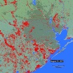
Mapped: Flooding in the Gulf Coast via Satellite
URBAN EDGE :
More maps confirm the massive scale of Harvey's devastation.
Mapped: Flooding in the Gulf Coast via Satellite
More maps confirm the massive scale of Harvey's devastation.
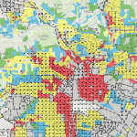
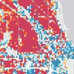
A new mapping tool overlays current demographic data with historic redlining maps.
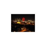
Why Does Houston Seem So Young?
Houston was founded in the 1830s, but a look at these maps reveals why it doesn't feel very old.
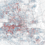
Houston in 2016, As Told Through 5 Maps
These maps reveal the level of economic and racial segregation in Houston -- and point toward a worsening divide.
How Do You Map the Character of a City? A New Tool Offers Solutions
The historic character of a community is often obvious. But in some places the past is less obvious and its significance harder to protect
10 Last-Minute 2016 Holiday Gifts for Urbanists
Nothing shows you care like a city-themed knick-knack.
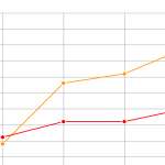
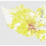
These Charts Show Poverty's Startling Spread Across Houston
Houston's economy has surged in recent years. So why is poverty expanding here?
What the Latest Version of Google Maps Tells Us About Cities
Google's efforts to highlight "areas of interest" reveals much about the development of Houston. It also says something about the way Google portrays urban life.
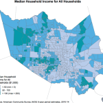
Where Do Houston's Renters Live?
How a new mapping tool can help change the way we think about renters and homeowners.
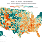
In the Wake of State Supreme Court Ruling, A Look at Texas School Funding
How Texas education funding stacks up against the rest of the country.
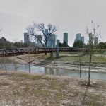
You Can Now Visit Houston's Trails Without Leaving Home (But You Probably Should)
A new partnership means more than two dozen of Houston's parks and trails are now available via Google Street View.

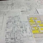
Mapping a community one parking spot at a time
Maps are one way to represent how we understand a given space.
Rice University
Kraft Hall
6100 Main Street, Suite 305
Houston, TX 77005-1892