
Not all who wander through the parking lots of Rice Village are lost. Some just might be counting cars.
Parking has been a decades-long headache in the area just west of Rice University known for its restaurants and shops. There have been no shortage of studies and proposals that seek to address the problem. So far, though, they haven’t put much of a dent in the continuous street congestion caused by an apparent shortage of parking and drivers circling the area in search of the perfect, free spot.
This spring, Rice graduate students from Dr. Michael Emerson’s urban sociology class counted (and dodged) cars in private and public surface lots, on-street, and in parking garages as they tried to assess the area’s parking patterns. Their results: the most comprehensive set of data documenting the Village’s parking patterns in years.
This blog won’t offer any new suggestions about how the Village can address its parking problems – at least not yet. A formal report on the parking study’s findings and a broader look at policy options for the area will be released in the coming months.
In the meantime, I want to talk about maps. Specifically, the evolution of the maps made for count itself.
Maps are one way to represent how we understand a given space. They often present the biases of their maker. While a professionally-designed map might push roads and offices to the forefront for navigation purposes, a handmade map might highlight pedestrian paths and small pockets of recreational space along one’s daily route.
The way we visualize an area, whether in our imagination or on the page, can tell planners, shop owners, engineers and policymakers a great deal about how users interact with a given location. That’s why professional planners often ask stakeholders to draw or build their ideal version of a place during the planning process.
Parking count maps likewise give planners and officials a great deal of information about the function of a space. Linked to the hard data collected through counts, maps highlight which parking lots are full or empty -- and when. The final GIS-rendered products we will produce do not quite capture the same imaginative wanderings of an individual’s mental map. But the process I went through to reach our end results reflected my own experience of walking, counting, and sketching the streets and parking spots of Rice Village.
Walking, drawing, mapping, and counting parking spots in Rice Village did more than give me a better sense of where I should park when I want to get breakfast at Torchy’s Tacos. My knowledge of the area has grown immeasurably by documenting and experiencing the space both physically and from afar. I know concrete facts—that there is an alley between Kelvin Dr. and Morningside Dr. with three private parking lots—and can now recognize more ephemeral patterns, like the shifting flow of car traffic and shoppers in and around the shops.
But the process wasn’t simple.
I am not a good drawer. I’ve know that since a young age when my first doodles – a go-to image of a desert island castaway leaning against a single palm tree as two shark fins circle the water – failed to win plaudits. But, nonetheless, freehand blocks and parking lot lines were where I started with the parking count maps.
With guidance from Kinder Institute guest speaker Patrick Seigman, a parking and urban design consultant from the planning firm Nelson/Nygaard, I first conducted a full inventory of the count area.
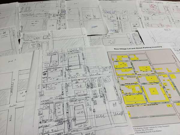
Starting from Google maps satellite images, I sketched out a rough version of the road grid and parking lots I expected to find on the ground. I needed something I could take into the field to do the inventory. Drawing the lines, rather than heading off with a printed aerial view, offered the chance to immediately learn more about area.
The translation from satellite to sketch was far from orderly. I drew blocks and lots out of scale. As I quickly penciled in the outlines of the area, I found myself ignoring the accurate depictions of roads offered by Google and trying to save time by using my own memory to complete the grid. This attempt was not as successful as I imagined it would be. The crossed out portions of Amherst Street and the building that bisects an arm of Bolsover Street, visible in the map below, attest to the inaccuracy of my mind’s eye view.

When I took my draft map to the Village to confirm the presence or absence of parking lots and to record the on-street parking areas, I found other inconsistencies between the screen and the street. Since Google isn’t updated as quickly as our actual land is developed, some parking lots hadn’t appeared on the satellite imagery. Others were obscured by trees or buildings. Some of the on-street parking spots I saw online were actually illegally parked cars. Some lots were filled beyond capacity with double-and-triple parked employee cars jammed into the back corner. My map continued to shift, and squiggled erasures found there way onto the page.
For the benefit of the graduate students, I formalized my fact-checked base map. I zoomed in and cleaned up the parking lot outlines and noted the number of spots in each lot. I even shaded the negative space that represents buildings (perhaps this activity did improve my drawing skills). This view made it clear that parking maps are nothing if not an interesting way to view urban spaces.

I used these cleaned up versions as the guide for a final set of maps for the count itself. I divided the lots and streets into 10 roughly equal sections by number of spaces and distance covered by the student. For these maps I made the revolutionary choice to use a ruler and drew the sections to scale. I gave these maps to the graduate student counters, along with spreadsheets of the complete inventory, a description of each parking section within their assigned area, and a blank sheet for the count.

With the data in hand (and a filled spreadsheet is certainly its own strange form of map), I finally turned to GIS. The below map is the baseline inventory of parking in the Rice Village area. Lots, garages, and pull-in parking sections are shown in yellow. On-street parking is shown in green. The lines are more straight and the words more legible.
While fictional parking lots have been removed, my own mapmaking biases remain. I created the parking lots and street sections within GIS, guided by aerial imagery. The final outlines, though, reflect the choices I made during the inventorying process. Should that set of street parking be considered one section or two? Do I divide this parking lot into individual sections by business or count it as one whole? Ultimately, what seem to be a collection of trivial choices, instead add up to make a map different from one produced by anyone else. The way we choose to see and record a space alters the way we represent it.

Data and counts can tell us a lot about macro-scale patterns and shifts invisible to on-the-ground observation. But without linking that data to tangible experiences of crossing streets, counting cars and witnessing the day-to-day ebb and flow in the Village, solutions to a wide variety of problems – from parking to encouraging more economic activity – will be harder to find.
The evolution of our parking count maps, from just a step above doodle to neat and informative, reflect this needed mix of macro and micro; of policy ideas and lived experiences. Check back in a few months to see the numbers from the actual counts and our report on how Rice Village stakeholders could improve the district.
And of course, don’t forget to keep an eye out for more maps.