The federal government’s proposal for a redrawn flood map would bring nearly 200 more square miles of Harris County into floodplains, a significant expansion with implications for property owners, renters and governmental leaders, a new Kinder Institute for Urban Research analysis shows.
Wide swaths of Harris County, particularly on the northwest and northeast sides, would be added to floodplains under the new map crafted by the Federal Emergency Management Agency, or FEMA. About 175,000 housing units and at least 170 government buildings would move into a floodplain after previously sitting outside of the zone, while around 60,000 housing units would leave a floodplain.
Federal officials remain at least two years away from giving final approval to the map, which will undergo a lengthy local and national review process. FEMA has not comprehensively updated the map since 2007.
The update will have wide-ranging effects on property values, insurance requirements, infrastructure planning and development regulations throughout Harris County.
The most significant impact would be felt by property owners and renters newly included in a floodway or 100-year floodplain, FEMA’s two highest-risk designations. Those added to the 500-year floodplain, FEMA’s lowest-risk designation, would see more minimal effects.
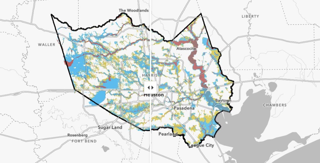
As Harris County property owners brace for the update, these three Kinder Institute maps show how Harris County floodplains would change, which neighborhoods would feel the biggest impact and which government facilities would get added to a floodplain.
The big-picture look
Under the current FEMA flood map, nearly 640 of Harris County’s 1,777 square miles fall within a floodplain. Most of those areas are located close to bayous, rivers, reservoirs and other major waterways.
Nearly 90% of those areas, totaling 571 square miles, would remain within a floodplain under the newly proposed map. Another 265 square miles of land would be added to a floodplain, often in areas located near a major waterway but farther from water sources than properties currently in a floodplain.
The remaining 10% of land currently within a floodplain, totaling 66 square miles, would be removed from the map.
With the additions and subtractions, the amount of land within the 100-year floodplain would rise from 301 to 445 square miles, while the 500-year floodplain would grow from 210 to 268 square miles. The size of the floodway would slightly shrink from 126 to 124 square miles.
The neighborhood level
Roughly two-thirds of Houston neighborhoods would have more homes in a floodplain under the new map — and in some cases, the additions would total thousands of units.
The greatest impact would be felt in the Cypress area, where four neighborhoods alone would see a net increase of about 24,500 single-family homes and 6,100 multifamily units added to a floodplain. Multiple creeks and White Oak Bayou run through those communities.
A cluster of five communities in northeast Harris County also would combine for a net increase of 18,500 housing units moved into a floodplain. Swaths of those neighborhoods were pummeled by flooding from creeks, bayous and the San Jacinto River during Hurricane Harvey.
Aldine, Pasadena and the far western edges of Harris County also would bear some of the biggest brunt of the change.
Conversely, the South Belt/Ellington neighborhood in southeast Harris County would draw the most relief, with a net decrease of 13,000 housing units within a floodplain. In Alief, nearly 9,300 net residential units would be removed.
The public facilities outlook
Schools, fire stations, police outposts and wastewater treatment plants across Greater Houston would see their flood map status change under the proposed map. The shifts could impact insurance, repair and development costs shouldered by taxpayers. The facilities also serve as emergency response and community hubs during natural disasters.
About 110 public school campuses would be newly designated in a floodplain, with the largest concentration located in the Houston, Cypress, Aldine, Pasadena and Spring independent school districts. However, nearly 100 campuses would leave a floodplain, mostly in Alief, Houston and Pasadena ISDs.
About 40 municipal wastewater treatment plants would be newly designated in a floodplain, with nearly half located in the Cypress area, while three would fall from the map.
Harris County is home to about 450 municipal wastewater treatment plants, the vast majority of which are small and serve unincorporated areas. Plants rendered inoperable during Hurricane Harvey dumped tens of millions of gallons of raw sewage and industrial discharges into nearby communities and waterways.
While 15 fire or EMS stations would be newly designated in a floodplain, another 20 would be removed. Just two police stations would get added to a floodplain, with three removed from the list.