
In the wake of Harvey, there's been a need for good data: whether it's emissions information from industries along the port, maps of the flooding to see which areas were hardest hit or information about students who have been shuffled around after their schools suffered damage from the storm. As part of an ongoing effort with its roots well before storm, the Kinder Institute is unveiling its Houston Community Data Connections dashboard. After gathering and geocoding a number of datasets, the Kinder Institute's data team, led by Jie Wu and Mingming Zhang, created a visualization tool that allows users to visualize several layered datasets at once.
Notably, the datasets include flooding information that can then be layered with various neighborhood indicators to see which populations were most affected by Harvey. But the dashboard can be used for a wide range of research and is targeted to community organizations, non-profits and policymakers.
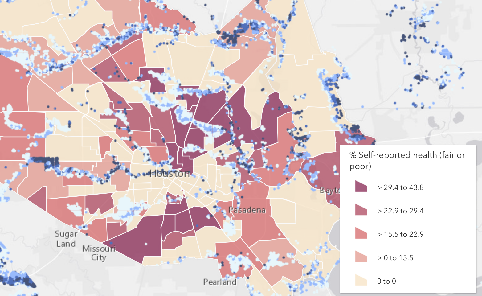
How will Harvey hit people who lack health insurance, for example? There is a clear geographic divide between the west and east side of Houston when it comes to health insurance. Though the flooding, with estimated levels shown above in blue, hit across Harris County and beyond, certain neighborhoods have underlying challenges that will likely be amplified following Harvey.
Neighborhoods in north and east Houston, for example, have almost a quarter of their populations without health insurance. They also experienced substantial flooding, suggesting that in addition to the usual risks posed during the cleanup process, the population there may have fewer resources to handle flood-related health issues in the days and weeks to come.
And in Houston, where diversity again gained headlines after Harvey, how did Harvey hit one of the most diverse cities in the country?
Using an index that measures how heterogenous or homogenous neighborhoods are, the map above shows the diversity of Houston's communities against flooding data. Neighborhoods in southwest Houston and some of the city's suburbs, including Pearland, are among the most diverse as well as hardest hit.
A look at areas with high percentages of renter-occupied units that also experienced flooding can reveal specific neighborhoods that may be struggling with possible evictions - problem the mayor has highlighted - in addition to struggling to recover after the floods.
Legal aid resources could be directed to those neighborhoods.
With much of the debate following Harvey centering around land-use development practices and regulation, important flood mitigation measures, like conserving natural wetlands, adding detention ponds and building with permeable surfaces were brought up as possible solutions.
A look at the extent of park land per neighborhood in relation to the flooding experienced during Harvey could frame those conversations. Some of the communities that experienced severe flooding had significant park space but many did not.
In response to the widespread devastation, the Houston Independent School District, the largest in Texas but not the only district in Houston, said it would extend its free lunch program to all students throughout the year and has had to shuffle students to different schools as recovery efforts continue. A map that shows where school-age children live as it relates to flooding can indicate some of the areas that might have the highest need inside the schools, both materially and emotionally.
"A catastrophe such as a flood is frightening to children and adults alike," the district wrote on its website. "Following a disaster, people may develop post-traumatic stress disorder (PTSD), which is psychological damage that can result from experiencing, witnessing or participating in an overwhelmingly traumatic event."
The Kinder Institute will continue to add new data to the dashboard. Certain datasets won't be available to every user but can be accessed with permission. For more information about the dashboard, head here.