
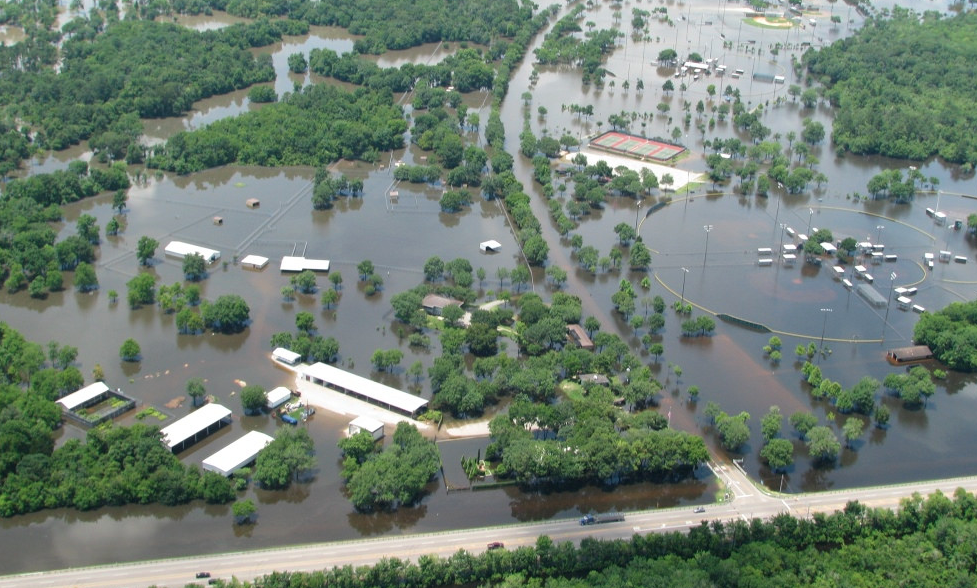
The 2015 Memorial Day floods hit the southwest Houston neighborhood of Meyerland particularly hard. Then, less than a year later, the neighborhood succumbed to another round of flooding. Many families had just completed repairs to their damaged homes when then rain came in April of 2016. Many residents felt hopeless after seeing all their repairs undone.
Meyerland has a long history. The deed-restricted suburban community opened in 1955 with a ribbon-cutting ceremony by then-Vice President Richard Nixon. But now, many are questioning the area's long term sustainability.
And more broadly, across the region, Houstonians are asking: is constant flooding the new normal?
Yes, says Kinder Institute Fellow Sam Brody, a professor with the department of marine sciences at Texas A&M University at Galveston. "We're celebrated for our economic growth," he said, "but at the same time, we're being dragged down by chronic and acute flooding events."
Along with a team of researchers, Brody works with data from the Federal Emergency Management Agency to plot insurance claims following flooding across the Houston metro area. Tracking the insured damage from 1972 to 2015, Brody identified a huge spike in costs after 2002, with cumulative costs reaching around $60 billion by 2015.
Many of the claims fell within what's known as the 100-year flood plain, where properties have an annual 1 percent risk of flooding. But plenty of others were outside the plain. These are places that didn't used to flood, residents will tell you, but now they do.
What changed is a story familiar to anyone living in Houston: rapid growth. "You take that landscape of physical risk, add 6 million people, and you get a landscape of loss," Brody said.
While Houston's natural vulnerabilities and climate change have contributed to worsening flooding, the larger driver is development and the loss of wetlands. "The problem is not Meyerland," he said. "The problem is upstream."
The explosive growth north and west of Houston has transformed the landscape and the way water moves through it. Since the 1950s, the Houston area has lost some 65 square miles in wetlands, according to coastal ecologist Erin Kinney, with the Houston Advanced Research Center. "Wetland alteration is the most important indicator of flood damage in the built environment," she wrote.
And the growth has only accelerated in recent years. Between 1996 and 2011, the Houston area saw a 25 percent increase in impervious surface, according to Brody. Along the way, the metro area lost evergreen forest, freshwater wetlands and pasture. The worst culprits weren't the developments in the dense urban cores; they were sprawl. His team found that high-intensity development decreased flood damage losses over the study period, while low-intensity sprawl amplified it.
Though the city and some developers have relied on retention ponds and other drainage fixes to try to mitigate flooding, it hasn't been enough to undo the damage caused by paving over wetlands. "Houston is now spending millions of dollars to fix the symptom, not the problem," said Brody of the retention ponds.
And a Houston Chronicle investigation published in April found that in many instances, flood mitigation that was supposed to be done by developers never actually occurred.
"...a review of a statistical sampling of permits issued to local developers by the U.S. Army Corps of Engineers found more than half were not in compliance. Those permits required the developers to take certain steps to mitigate wetlands destroyed by their construction. But apparently the work was not done."
Looking at the permits issued for altered wetlands, Brody said, "There's this cumulative death by a thousand cuts approach, and it's only getting worse." His team has been busy creating projections of future development into 2100 and the maps they've created show not only the spread of impervious surface cover but also blooms of similar development ringing the metro area.
Solutions will require a mix of interventions including wetland restoration, embedded open spaces, elevating existing properties in some cases and a potential, if controversial, barrier along the coast, a la the Ike Dike.
"There are no easy answers," said Brody.
This story was originally published November 30, 2016.