We all know the story by now. Hurricane Harvey has been framed as a problem of urban form: a challenge created by the collision of intense rainfall and urban sprawl. Indeed, Houston has acquired an international reputation as the textbook example of unchecked growth. Growth that was allowed in sites that should not have been developed in the first place, like flood plains, wetlands, and spillways. In fact, both the city’s lay out (where it is built) and the prevalent building typologies (what is built) exacerbate flooding. Images of the sprawling metropolis usually show an aerial of unanimous single-family detached homes: of low-density, car-dependent, mono-functional development. Underserved in terms of storm water infrastructure, Houston’s built environment is predestined to flood.
But the real question is: what, exactly, is wrong with Houston’s growth and urban development pattern? A point of departure can be found in comparing Houston to other regions. And where better to start then in the Netherlands, the globe’s leading nation in water management? Known as the country that has the highest flood risk on earth, the Netherlands has not experienced a large flood event since 1953. It is located in the delta of multiple European rivers, and half of its swampy soils lie below sea level. By all rights it should be underwater, but a centuries-old tradition of water management prevents this. Relying on a national system of flood defenses and 24/7 drainage by pumps, the Netherlands is proof that storm, surface, and seepage water can be successfully contained.
The Harvey floodings, understandably, make Houstonians look abroad for fresh ideas and best practices, like those from the Netherlands. But knowledge gathering should not be a one-sided endeavor. In fact, the need for knowledge exchange runs in both directions. The success of the Dutch approach created its own, local challenges. And Houston, with its regular experience of flooding, may very well have solutions to Dutch issues. Any comparison, however, requires an understanding of the different histories and context.
So first, let’s get introduced.

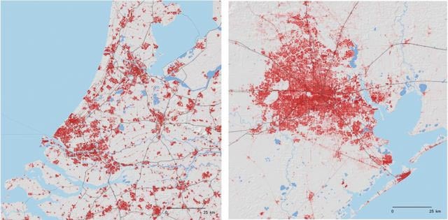
Density of maps of Randstad (left) and the Houston area (right).
The Netherlands has its own “metropolis” called the Randstad (Edge-City), a conurbation that includes cities like Amsterdam, Rotterdam, and The Hague. In sharp contrast with Houston, where uncontrolled urban development is pushed by non-governmental entities like Municipal Utility Districts (MUDs) and Municipal Management Districts (MMDs), Randstad is the textbook example of controlled development. Formerly known as a “planner’s paradise,” the Netherlands has been famous for its strong national planning ideology, where new development was governmentally guided to “new towns” to prevent sprawl.
An abundance of structural measures that protect against flooding, and powerful landuse policy would make one think that Randstad has addressed all its water issues. However, as I will explain below, it has its own demons to face.
The above maps demonstrate the status quo of the built environment of both the Randstad and Houston conurbations in 2012, on a 25-kilometer scale. With an area of approximately 1,700 square miles and 7 million residents Randstad is comparable to the Houston region. Also similar is the elevation (flat as a pancake), and the location on large bodies of open water (Galveston Bay, southeast, and Lake IJssel, north). The maps tell us something about urban form, and they confirm our suspicions: Houston does indeed have a sprawling layout, with low densities and little open green space, as compared to the Randstad. The maps tell us something about urban form, but not about the pace of development, or the types of buildings that constitute the urban fabric. The next set of maps, focused on an area the size of Harris County, reveals more differences. This form of mapping is called chronological development mapping: it reveals the age of the existing development in layers.

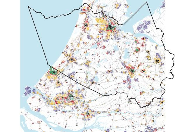
Chronological development of Randstad with outline of Harris County.
Courtesy Randstad-Holland research-group.

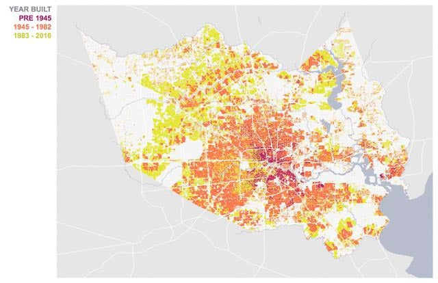
Pre-1945, 1945-82, and 83-present buildings in Harris County.
Courtesy Kinder Institute, source HCAD.
The maps were produced by a research group at Delft University, called Mapping the Randstad Holland (in 2007), and Kelsey Walker, a researcher at Rice University’s Kinder Institute (in 2017). When comparing the maps, one thing immediately seizes the eye. First of all, the Randstad-conurbation is not just dense, it is mostly old. While Walker could suffice with three chronological layers (pre-1945, 1945-1982, and post 1982), the Randstad’s cartographers needed four to identify sizable parts of the urban fabric (pre-1850, 1850-1940, 1940-1970, 1970-2000). Most cities in the Randstad conurbation developed from the late thirteenth century, and ‘came of age’ in the fourteenth. When Houston was founded in 1836, Randstad already went into its second round of growth.
Both chronological development maps have been linked to prevalent building typologies within the urban fabric. For Houston, the switch from grid-based to spine-based urbanism in the post-1945 layer has been noted by Albert Pope, Professor of Architecture at Rice University. In the Randstad, prevalent building typologies also changed within each layer. According to Henk Engel, emeritus professor of Architecture at Delft University, canal-houses with mixed uses dominated before 1850. From the 1850s onwards streets replaced canals as the binding elements in the urban fabric. In the 1920s and 1930s the first “large-scale” housing estates were built, with a uniform architecture; followed by modernist planning extensions (high-rise blocks) and single-purpose “cauliflower estates” in the 1970s and 1980s. The youngest layers are the so-called VINEX estates from the 1990s.
What is key here, is that the majority of Randstad’s urban fabric consists of post 1850s building typologies that, like Houston’s built environment, were not designed to flood. That is, the buildings and streets cannot accommodate water: they were designed on the assumption that no flooding would occur. So, despite the Dutch being global leaders in flood management, the type of problem that affects Houston nowadays is not entirely unknown in the Netherlands. Precipitation increasingly presents itself in the form of intense rainfall events. And although Randstad’s rainfall-issues are not even close to those of Houston, mobile pumps are required more often to drain cities, like The Hague, after a summer’s deluge. In response, Dutch national government has kicked of a national “spatial adaptation”-program in September 2017. It calls upon local government to perform so-called “stress-tests,” that identify weak spots in the urban fabric that underperform in times of prolonged drought or heat, and intense rainfall.
How is it possible that a metropolis that has been sinking below sea level for centuries, and has a spatial planning ideology to guide urban development, is still overwhelmed by pluvial flooding? The answer is that the Randstad has relied on a set of regional and national solutions to keep storm, surface, and seepage water out as much as possible. This “up-scaled” approach has been so immensely successful, that it relieved planners, urbanists, and architects from the obligation of designing for flood-prone conditions.
Flood control in the Netherlands was the job of regional institutions called water boards until the second half of the nineteenth century. Water boards were collective entities that managed local dike rings called polders, not unlike the Levee Improvement Districts in Fort Bend in Texas. Despite regular maintenance and continuous pumping by windmills, farmlands were usually submerged during wintertime. Seasonal flooding kept an “amphibious culture” alive, where farmers built two-story sheds to shelter the cattle, and city ramparts co-functioned as levees.
In the second half of the nineteenth century, the Rijkswaterstaat — the Dutch equivalent of United States Army Corps of Engineers (USACE) — up-scaled regional water management-practice into a national system. It constructed and managed levees of national importance, like the world-famous Delta Works, too expensive or technically too complicated for the water boards. Windmills were replaced by pumps and the seasonal flooding that kept development out of the deepest polders, disappeared. In this period, the Randstad conurbation grew its 1850s-1940s (green) layer, with streets that rather than canals. Large dams and flood-gates, maintained at safety standards as high as 10,000-year flood events, relieved Dutch citizens from even thinking about flooding. But the unprecedented success of Dutch mega-engineering had some collateral: the “amphibious culture” of the Netherlands was completely lost. And while the Randstad became the international benchmark for planned urban growth (watch for the yellow and purple-layers on the map), new un-amphibious development was guided into the deepest polders.
Thus, the combination of a strong national planning ideology and an even stronger trust in flood prevention via the construction and maintenance of structures gave the Netherlands a contained metropolis that was nonetheless never built to accommodate water. In fact, the largest part of its urban fabric consists of building typologies that were not designed to flood. The average Dutch citizen nowadays has a very low awareness of flood risk, and evacuation plans for flood events are few (if any). Now, with the increasingly common intense rainfalls, the amphibious approach — one in which the built environment accommodates water, like those old two-story barns — is sorely missed.
Now let’s get back to the Houston metropolis. In Raj Mankad’s analysis of the Walker maps, he notes that Houston is not only young but it is younger than its birthdate indicates. The overwhelming majority of development has occurred within the last 35 years, and grand swaths of the old city have been replaced with newer buildings in the 1983-2016 period. Houston has a very small early-century footprint, with only 6.1 percent of Houston’s building stock being pre-1945, 47.7 percent between 1945 and ’82, and 46.3 percent after ’82. Compared to the Randstad, Houston is literally just coming of age.
The comparison of Houston with the Randstad-conurbation teaches us two things.
First, Houston’s urban dynamics are extremely high. Both in terms of expansion as redevelopment. The Randstad-map stops in 2000, but that does really not matter: millennial development has taken place predominantly within the existing urban form, in the conversion of abandoned brownfield sites to mixed-use neighborhoods. With the Dutch moderate pace of development, the 2017 map of the Randstad still looks very much like the 2000s-version. Compared to Houston (which has acquired 25 percent increase of population since 2000) its current pace of (re)development is very slow.
This, in fact, puts Houston in a much better position to adapt its built environment to flooding then then the Randstad. Randstad may have a consistent spatial planning system and a fairly uniform form of local governance to guide development patterns – but these assets may be of little use when development itself is slow. For Houston, it is the other way around. It has high urban dynamics, but little in the way of a consistent regional strategy to put those dynamics to work.
Would it be possible to imagine a future for Houston where its unique strength – high urban dynamics – are mobilized to make its urban fabric less rather than more vulnerable to flooding? The current global move towards concentration of development in flood prone areas, combined with severe storms and increased precipitation, calls for a rediscovery of amphibious cultures. That is likely to be a combination of structural flood defenses, evacuation strategies, and adaptation of the built environment.
This bring us to the second conclusion. In the global quest for the mitigation of flood damages both Randstad and Houston have something to bring to the table. The regular experience of flooding has given Houston a portfolio of local solutions to flooding that would amaze the Dutch: Texas Medical Center, retrofitted after tropical storm Allison, is a good example. Equipped with an early warning system, elevated entrances, flood berms, skytunnels, an abundance of flood doors, and its own electric facility protected by a levee, it has remained operational throughout the Tax Day, Memorial Day, and Harvey flood events. Houston also has regular experience with evacuation and its limitations, techniques that have not been called upon for a while in the Netherlands. Randstad boasts a portfolio of national and regional solutions, based on keeping storm, surface, and seepage water out, and a regional outlook on spatial challenges like development. Houston can benefit from learning about these approaches. They can meet half-way.
This article was originally published on OffCite, the digital home of Cite: The Architecture + Design Review of Houston, a quarterly publication of the Rice Design Alliance.

