
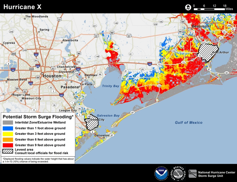
 As experts anticipate a busier 2016 hurricane season, the National Hurricane Center released a new, interactive map of potential storm surge flooding which will be updated for new tropical cyclones. A static image of a hypothetical storm shows how the map will look.
Hurricane season began last week, as the Houston area dealt with another round of rain and flooding (albeit not hurricane-related). And unfortunately for the water-weary coastal city, experts predict this year's season will be "near-normal," which is to say, slightly more active than the past few years, when Houston hasn't faced major hurricane threats.
According to the National Oceanic and Atmospheric Administration's Climate Prediction Center, the East and Gulf Coasts could see 10 to 16 named storms this year, with winds at 39 miles per hour or higher, including one to four major hurricanes, with winds of 111 miles per hour or higher.
And, because of population growth between 2006 and 2015 along the coast from Texas to North Carolina, an additional 3.1 million people could be affected by those storms, according to the Census Bureau.
Forecasting is tricky business. The greatest odds -- 45 percent -- call for a "near normal" season. But there's also a 30 percent chance of an above-normal season and a 25 percent chance of a below-normal season, according to NOAA.
“This is a more challenging hurricane season outlook than most because it’s difficult to determine whether there will be reinforcing or competing climate influences on tropical storm development,” said Gerry Bell, Ph.D., lead seasonal hurricane forecaster with NOAA’s Climate Prediction Center in a statement. "However, a near-normal prediction for this season suggests we could see more hurricane activity than we’ve seen in the last three years, which were below normal.”
NOAA's Hurricane Center also released a new, interactive map to show potential storm surge flooding for certain tropical cyclones along the East and Gulf Coasts. The map doesn't take into account flooding from rainfall or levee failures but will instead focus on coastal flooding caused by storm surges, which accounts for roughly half of all deaths associated with tropical cyclones, according to a 2014 study.
That study, by Edward Rappaport of the Hurricane Center, also found that while the entire Gulf Coast is vulnerable to tropical cyclones, Louisiana and Mississippi appear to be particularly vulnerable. So while the two states had fewer storms make landfall than Texas, they saw seven times as many deaths per landfall event. Even excluding Hurricane Katrina, which claimed some 1,100 lives, Louisiana and Mississippi still saw three times as many deaths per landfall than Texas.
In Harris County, Judge Ed Emmett is in charge of disaster response, as director of the Harris County Office of Homeland Security and Emergency Management.
Emmett sat down with Houston Public Media to talk about the start of hurricane season. Read the full interview here.
Related items from the Urban Edge archives: